
source: https://decolonialatlas.wordpress.com/2017/04/18/colorful-river-basin-maps/
It has more detailed maps for each continent too.
You must log in or register to comment.
It has more detailed maps for each continent too.
The continents being North America, Africa, Australia, Europe, South America, Great Britain, and China :)
brexit means brexit
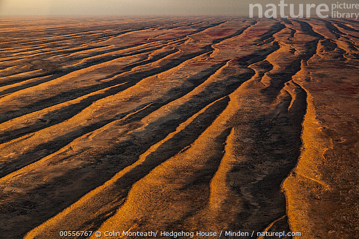
What’s with blob of parallel watersheds in the middle of Australia?
I checked on google maps, it’s the Simpson Desert, it kinda looks like that. Anyone know why?
Wikipedia says:
The Simpson Desert is an erg that contains the world’s longest parallel sand dunes.
I’m guessing this part of the map uses the actual surface topography, ie how precipitation would run off through the troughs of the dunes, rather than the underlying aquifer structure. Hmmm 🧐.
Why do they all run straight for hundreds of miles? None of the other deserts are like that.
It’s the predominant direction of the wind.
It’s just more efficient to manage. We got to do a lot with very little.
Seems like the sand dunes got locked in place by vegetation at some point. It was shaped by the wind whe it was even drier than today, but then stopped moving when there was just enough moisture for plants to get a hold of things
This is just a guess, but looking at satellite images it looks like there could be dry river beds in the desert. Maybe the area gets enough rain to have them, but not enough for them to lead anywhere.
And people think I’m a fool for living in New Orleans. All your water are belong to us.
So this shows the different times around the world that naughty stuff can be shown on TV, neat

